Spring
advanced
1-20 Pax
6186m
23 Days
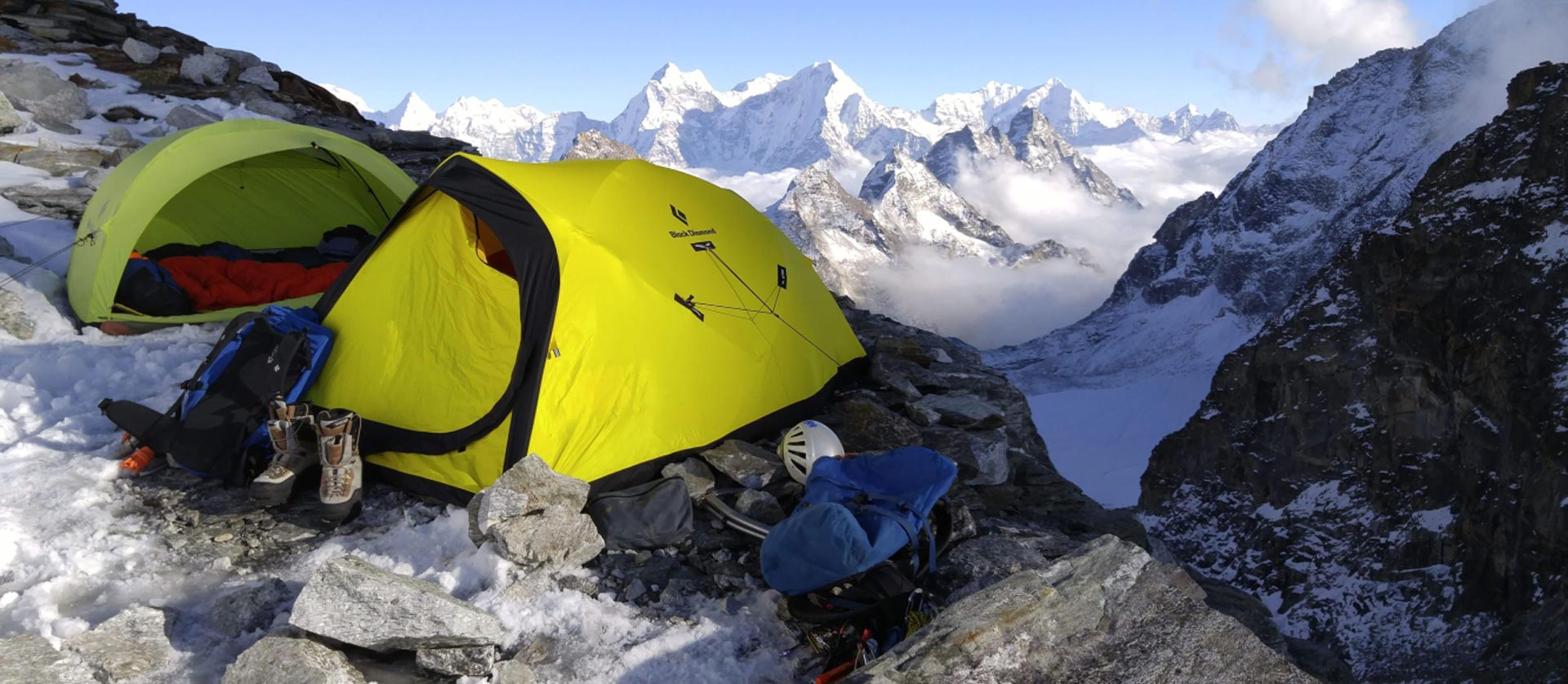
The Kyajo-ri expedition is recently opened a very beautiful peak located in Gokyo valley in Everest region. It stands on 6168 meters high with beautiful land scope valley. From the Kyojo-ri we can enjoy with many mountains view in the Everest region including some of the eight thousand peaks (Everest, Lhotse, Makalu, Cho-Oyo).
Kyajo-ri is one of the technical peaks with moraine, Glacier, bouldering, rocks ice and snow. So, it seems more technical and different compared with other 6000 meters peaks in Khumbu valley.
Before the expedition, there is a trek with high pass Renjo-la pass (5320m.) to acclimatize for Kyajo-ri .
23 Days – Detailed Itinerary
On arrival, our staff will receive and transfer you to the respective Hotels.
These days will be used obtaining necessary paper works and documents with the Sherpa staff, making of the climbing permits, Visa and a visit to the Ministry of Tourism for Official briefings.
We go to Kathmandu domestic airport to take a nice, short flight to Lukla, Tenzing Hillary airport, the start point for the trek to EBC. We will see many beautiful mountain ranges such as Langtang and Jugal ranges, then the Rolwaling Himal and Mt. Gaurisankar before getting to see the first view of Mt. Everest on the flight. We make a short stop in Lukla to sort out bags etc before setting off. It is a nice short walk for the day 3hrs walk through low rhododendron forest, small villages, and farms. We will pass through many and small Mani Stone, Chhortens and prayer wheels which are built to after good luck for all the living beings. We will set to Phakding for lunch and we have all afternoon to take a food rest or look around the Phakding tour which lies along with the banks of Dudh Koshi River.
After early breakfast at lodge, we trek to Namche following with the bank of Dudh Koshi River. We will get good view of Thamserku Peak (6623m) on the way and pass small villages and firm. Walking along a path with many ups and downs, crossing a stream we will reach to village called Monjo at 2840m gaining 230m more from Phakding. We stop for lunch here. After lunch we go through the National park Entrance Gate where we pay our N.P. entrance fees. We carry on walking on the bank of Dudh Koshi River for 45 minutes to 1hr and then we start ascending uphill towards Namche start with crossing big and tallest suspension bridge in Khumbu valley. While ascending uphill we reach to rest joint called Top Dada where you will get the first view of Mt. Everest. From here you ascend gradually up to Namche Bazar. When we reach to Namche, we will gain about 800m of more altitude.
It’s an acclimatization day so, we’ll take a gentle walk to gain a little height and have a free afternoon. Your guide/ leader will take you to a couple of wonderful viewpoints to see the spectacular view of Lhotse, Nuptse, Everest, Amadablam etc. You should also be able to visit the monastery at Tengboche and the trails to Everest you can also visit couple villages of Khumjung and Khunde with their health post-school started by Sir Edmund Hilary.
After lunch, you are free to go around Namche Bazar where you can see lots of different shops and it is a good place to get a souvenir. You will see the trader with big groups of Yak. You can also visit Namche Monastery. The monastery is about 80 years old and has beautiful Thanka Painting of Tibetan deities. You can also visit Sherpa Museum lies just above the Namche town. There you can see the photo gallery of many famous mountaineers and record holders and the Sherpa Museum shows all the things and utensils use in Sherpa houses in the old days. Namche is the biggest town or market place in Khumbu region where people from different places come to trade their goods.
Approximately altitude gain about 760 meters
Trek starts along through the Everest Base Camp trek until an hour place called Sanasa on flat walk then separate rough to Gokyo Valley to the north of Sanasa with gentle slope about an hour. To the Mongla and trails drops down to the Phorechtanga where is Nepalese Army check post, trek continues with steep slope and gentle slope somewhere and you will be there at Dole which is about the tree line. During the day you will be able to see Mt. Everest, Lhotse, Nuptse, Amadablam, Thamserku, Khantega, Tabuche including Tenbuche Monastery and Phorche Village.
It is about 3 hours to get the camp need to ascend with 270 meters, trail start with steep slope about first 30 minutes then flat gentle slopes to the north of Dole with the first view of Mt. Cho Oyu (8210m) and many other mountains, you might feel altitude so requires to drink enough water and eat well.
Day 8. Macharmo to Gokyo (4790m) 3-4 hours slowly ascend about 320meters trails leads with gentle slope at beginning and follow flat and again gentle slope before get to the first lake of Gokyo. Walk along the Nujumbu glacier until the Gokyo. On the way to Gokyo, you will be able to see first lake, second lake and third lake with nice view of Gokyo Valley Mountains.
Slowly ascend about 320meters trails leads with gentle slope at beginning and follow flat and again gentle slope before get to the first lake of Gokyo. Walk along the Nujumbu glacier until the Gokyo. On the way to Gokyo, you will be able to see first lake, second lake and third lake with nice view of Gokyo Valley Mountains.
It’s about 3:30 hours from Gokyo Trail still follow to the left side of Nujambu Glacier until the Cho Oyu Base Camp which is the longest glacier of Nepal. With another view of Mt. Everest (8848m) to the east, 4th and 5th lake along the way, spending a few minutes at Gokyo and then again about 2 hours down.
Gokyo to Langden trail leads towards to the Northwest from Gokyo by the right of the third lake and slowly ascend to the Renjo Pass (5360 meters), it is about 3 hours to get the top (ascend about 600 meters) descend about (1000m.) to the Lungdeng, from the Renjo-la pass you will be able to see massive view of Khumbu Himal.
Lungden to Khumjung (3780m) 6 hours walks through the typical old Sherpa Village called Thame, Thamo Furteng also known as a famous Sherpa Everest summiteers village in the world. Trek continuous to the distinction after lunch at Thamo. After an hour of walk, trail separates to the left side to the Khujung. About 1:30 hours pass via Syangbuche Airport which is known as the highest airport of Nepal situated on an elevation of (3720m).
Rest day at Khumjung and checking gears, food, equipment to make sure again for Kyajo-Ri climbing.
Ascend (740m) Khumjung – Kyajo-Ri base camp (4530m.) 4 hours and trek start towards to the northwest of Khumjung pass through the Khunde village on flat about 40 minutes, then climb steep slope on grassy path until the southwest ridge of Khumbi-La about an hour walk, the trail drops down a bit narrow and rocky path and again a gentle slope following the water pipe which is serving to the Khunde and Khumjung village then you will get to the water source about 1:30 hours still need to go little further to Kyajo-Ri base camp, 30 more minutes on murrain and grassy flat.
The trail leads on flat first 20 minutes and climb steep scree, sandy and rocky Narrow circular until the ridge about an hour then trails leads on flat murrain and sandy until the bottom of Camp1 about 2hrs, again steep slope on murrain and scree path about 1:30hours to get to the Camp1 where is big glacier lake to the right of the campsite.
You really feel adventurous with walking on the murrain about an hour and start walking on the glacier with a crampon about 1:30hrs, then again on murrain and borders with steep slopes to the Camp2 then Camp2 is on the rocky section with narrow space.
To summit and back to Camp2 climbing start with first 3/ 4 pitches of rock then less 10 pitches of Ice and snowy part form the top of Kyajo-Ri. You get a Panoramic View of all Khumbu Himal including four 8000m peak like Mt Everest (8848m), Lhotse (8516), Makalu (8485), Cho Oyu (8188m) and also many 7000m and 6000m peaks in Everest region then spending few minutes on the top and descend down all the way to Camp1 on same day.
Camp 1 – Khumjung it’s about 4hrs. and descend almost (1600m) in the same way.
Khumjung- Phakding ( 2610m) 4-5 hrs and descend about 1100m. Passing via Namche Bazaar Jorsale, Sagarmatha National Park Check Post, Monjo and then Phakding.
Phakding lukla about 3 hours over night stay at lukla.
Lukla to Kathmadu Flight
Extra Day in Kathmandu
Flight back to home.
Everything you need for a comfortable and memorable trek
23 Days • No departure dates